

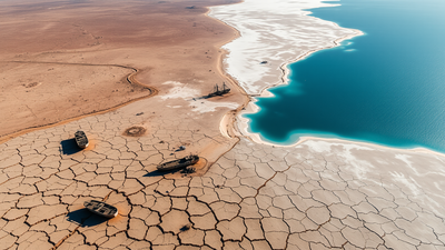
In 1960, the Aral Sea was ranked among the largest lakes on the planet, straddling the borders of what are now Kazakhstan and Uzbekistan. Within one human life, most of it was gone.
Soviet planners had redirected its two feeder rivers to irrigate cotton fields throughout Central Asia, and by the 1980s the lake was not receiving any fresh water at all. What followed was one of the most dramatic environmental collapses of the 20th century, as the inland sea split apart, turned toxic by salt residue and pesticides, and left fishing fleets stranded miles from any coastline. However, one corner of that story took an unexpected turn when a modest dam brought part of the sea back to life much faster than anyone expected.
How Soviet cotton planning drained the Aral Sea
The Aral Sea depends entirely on the Amu Darya and Syr Darya rivers, which transport melting snow from distant mountains into a lake with no natural outlet. Beginning around 1960, Soviet planners diverted large amounts of this water to irrigate cotton across present-day Uzbekistan, Turkmenistan, and Kazakhstan. According to NASA’s Earth Observatory, the Aral Sea received about 50 cubic kilometers of fresh water each year until 1965, a number that dropped to zero by the early 1980s when rivers were drained before they reached the lake.
A lake that split into pieces when it shrank
As the flow disappeared, the Aral Sea began to decline and divide. NASA’s “World of Change” series documents describe how the lake split into a northern and southern sea, with the southern part split into an eastern and western lobes that remained loosely connected before completely separating by 2001. Water levels in the eastern lobe fluctuated during the 2000s depending on drought conditions, and by August 2009, NASA images documented that almost nothing remained of what had previously been the lake’s largest lobe.
Salt, disease and stuck ships were left behind
Every bit of water that evaporated left its dissolved salts behind, steadily increasing the concentration in what was left. According to research published by geographer Philip Micklin at the Department of Lakes and Reservoir Research and Management, drought conditions across the Amu Darya Basin meant that almost no water reached the Aral Sea in 2007, and no water at all in 2008 and 2009, causing the eastern lobe of the Southern Sea to almost disappear. The retreating shoreline left entire fishing fleets stranded on a dry, cracked lake bed far from any remaining water, images that have come to symbolize the scale of the disaster in the wider region.
how Kuk-Aral Dam Brought part of the sea back
Instead of trying to restore the entire lake, a project supported by Kazakhstan and the World Bank focused only on saving the smaller northern section, which is still fed by the Syr Darya River. According to the World Bank’s own account of the project, the approximately 8-mile-long Kuk Aral Dam was completed in August 2005 and is designed to allow more than 29 cubic kilometers of water to accumulate in the Northern Sea, while the dam’s gate periodically releases excess water into the largely dried-out southern basin.
Masoud Ahmed, head of the World Bank task force on the project, said at the time that after decades of studies without any action, the project was finally starting to achieve measurable results.
Results that exceeded original expectations
The recovery has gone beyond what planners expected. A subsequent World Bank press release reported that the volume of the Northern Aral Sea had already risen by 68 percent by 2008, just three years after the dam was completed, while salinity had fallen by half and annual fish production had more than tripled compared to pre-dam levels.
These improvements allowed communities around the city of Aralsk to return to fishing as a source of income after decades of economic hardship following the original collapse.
Restoration efforts continue today
Work in the North Sea did not stop with the original dam project. According to World Bank project documents, another project to develop and revitalize the Northern Aral Sea aims to further improve water resource management in the Syr Darya Basin, along with restoring wetlands and supporting fisheries, agriculture and tourism in the surrounding Kyzylorda region. Meanwhile, satellite monitoring from the European Space Agency shows that the southern basin remains a mostly dry expanse now known as the Aralcum Desert, underscoring how the two halves of the same lake have followed very different paths since the dam was built.
Why does the Aral Sea remain a cautionary tale?
Overall, the story of the Aral Sea illustrates how quickly a large area of water can be lost due to short-term planning decisions and how targeted intervention can reverse some of this damage when applied consistently over time. The recovery of the North Sea provides a rare example of environmental recovery succeeding faster than expected, even as the larger southern basin remains a stark, dry reminder of what the entire lake once looked like before the rivers that fed it were diverted forever.