

Rivers are often treated as fixed features of the landscape. They bend, sink, and change over long periods of time, but they appear permanent enough that entire cities and economies are built around them.
The Mississippi River, in particular, has long been considered one of North America’s defining geographic features. However, in the early 19th century, a series of earthquakes briefly changed its behavior in ways that still seem improbable today. During the winter of 1811 and 1812, violent earth movements reshaped parts of the central United States, leaving behind altered river channels, newly formed lakes and a lasting reminder that even large rivers can be affected by forces deep beneath the Earth’s surface.
How 1812 New Madrid earthquakes It shook the Mississippi River area
The pre-dawn earthquake on February 7, 1812 was not an isolated event. It arrived after months of seismic activity that had already destabilized communities spread along the Mississippi Valley. People living in border settlements are accustomed to earthquakes, but the shocks continue to arrive with unusual frequency and intensity.What made the sequence great was its location. Major earthquakes are often associated with the western margin of North America, but these events occurred hundreds of miles from the nearest oceanic plate boundary.
The area around New Madrid, a settlement located in what is now southeastern Missouri, was at the center of the unrest. Although sparsely populated by modern standards, it occupied an important position along the river and served as a major stopping point for travelers and traders.
The earthquake that destroyed New Madrid and the Mississippi Valley
As the Watchtower Online Library reported, by the time the strongest earthquake struck in February 1812, many structures had already been weakened by previous tremors.
The last shock was much more damaging. Buildings collapsed, cracks opened in the ground, and large parts of the surrounding landscape changed suddenly.Accounts from the period describe a scene of confusion rather than a single catastrophic moment. The tremors were followed by aftershocks, then followed by other aftershocks. People struggled to determine whether the danger had passed as the ground beneath them repeatedly moved again.The settlement itself was severely damaged. Elsewhere along the river corridor, local communities have felt the effects even though they are located at great distances from the central region. Even places outside the immediate area reported shaking strong enough to cause concern.
The strange behavior of the Mississippi
The story most often associated with the New Madrid earthquakes concerns the Mississippi River itself.As the ground deformed, parts of the riverbed rose while other parts retreated.
This uneven movement disrupted the natural flow of water. Contemporary witnesses described strong waves rushing across the river, and in some places, the current appeared to reverse direction for short periods.The river did not permanently change its course nor did it begin to flow north in any permanent sense. What happened was more complicated. The sudden rise and fall created temporary obstructions and disturbances within the channel, generating powerful waves that moved upstream.
For observers following the events from the riverbanks or traveling by boat, the effect was striking enough to be remembered for generations as a river running backwards.To this day, this incident remains one of the most frequently cited examples of how earthquakes affect large waterways.
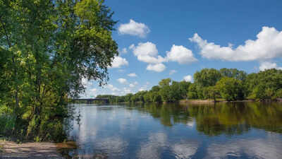
The earthquake that generated Reelfoot Lake
The landscape east of the Mississippi River underwent some of the most marked changes. In what is now western Tennessee, parts of the ground sank several feet as the earthquake sequence unfolded.
The newly formed depressions changed drainage patterns and created depressed areas capable of collecting water.Once the floodwaters spread across the flooded land, a new lake gradually appeared. As the USGS reports, this body of water became known as Reelfoot Lake, which remains a prominent feature of the Tennessee landscape more than two centuries later. Today visitors encounter a tranquil environment of shallow water, cypress trees, and abundant wildlife. Some evidence immediately suggests that the lake owes its existence to one of the strongest earthquakes in American history.
Its origins lie hidden beneath the surface, in a moment when the Earth itself changed dramatically.

