

An area of the Pacific Ocean has been quietly warming again, attracting the attention of meteorologists who spend their time observing patterns that most people never think about. The signals aren’t dramatic in and of themselves: a few degrees here, a change in sea surface temperatures there, and the winds are behaving a little differently than expected.
But these small changes tend to travel. El Niño is one of those recurring systems that starts far out at sea and then interferes with the weather thousands of kilometers away, sometimes in uneven and difficult to predict ways. As the National Oceanic and Atmospheric Administration (NOAA) reports, El Niño and high tidal flooding could create a “double whammy” for coastal communities in 2026. The US National Weather Service predicts that El Niño could develop by July 2026 and last into the winter, increasing the risk of coastal flooding in many areas.
El Niño is part of the ENSO cycle, a natural weather pattern that transitions between warm, cold and neutral phases in the tropical Pacific Ocean.
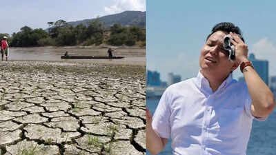
During El Niño, weak trade winds raise sea surface temperatures and sea levels, affecting global weather patterns. On U.S. coasts, this could mean higher tides, increased storm force, and heavy rainfall. Combined with long-term sea level rise, experts warn that flooding caused by high tides could become more frequent and severe, especially when El Niño conditions reach their peak in 2026.
El Niño 2026 :understand it Impact of uneven weather
The occurrence of El Niño looks a little different to those who track it. Warm water is accumulating in the central and eastern Pacific Ocean, disrupting the usual movement of air and rain across the tropics. This shift could redraw rainfall patterns across continents.In recent observations, sea temperatures in parts of the Pacific Ocean rose well above average during the latest cycle, making it among the strongest episodes recorded in recent decades.
The global picture has been broadly captured by forecasts, although regional results have not exactly followed the expected path. For example, California did not receive the regular winter rains often associated with El Niño years, while other parts of the United States experienced heavy and persistent rainfall.
Climate models are built on patterns, but the atmosphere rarely moves in straight lines. Small changes in jet streams can send storm systems hundreds of kilometers off course.
This is what happened along the West Coast of the United States, where rain was concentrated further north than many forecasts suggested.Scientists have reconsidered why some results deviate so sharply from expectations. Part of the difficulty lies in how multiple systems interact simultaneously: ocean temperatures, wind patterns, and longer-term global warming trends intersect. Even a well-established El Niño signal can be bent or attenuated by these competing forces, leaving gaps between prediction and reality.
What does “Godzilla El Niño” really mean in climatology?
The term “Godzilla El Niño” is not official, but has stuck in public discussion to describe more extreme versions of the phenomenon. These are periods when sea surface temperatures rise several degrees above normal, and the global impact becomes more evident.Past strong events in the early 1980s, late 1990s, and mid-2000s were associated with severe droughts, floods in unexpected areas, and widespread forest fires in parts of Southeast Asia and South America.
Some researchers are also drawing attention to potential links between stronger El Niño cycles and broader climate variability, although the relationships are not clear and remain debated.There have also been discussions in academia about whether solar activity, such as sunspot cycles, might have some influence on the behavior of the oceans and atmosphere. The evidence is far from settled, and most climate scientists treat it as an open question rather than a clear driver.
Farms, grids and slow heat compression
For agricultural areas, the impact is rarely immediate in one dramatic moment. It tends to manifest itself in adjustments: seeds planted later than usual, crop selections quietly changed in response to uncertain rainfall fluctuations, and irrigation systems extended beyond planned.When rainfall weakens, reservoirs refill more slowly, and dependence on groundwater becomes more severe. In cities, the consequences appear through pressures on water supplies that build up gradually rather than suddenly.
Energy demand tends to rise at the same time, as hotter days push households and businesses toward continuous cooling.According to PIB reports, India has already recorded peak electricity demand levels of more than 250 gigawatts in recent years, a figure that highlights how closely power systems track temperature changes. In a hotter-than-average season, this demand could rise even further, putting greater pressure on infrastructure that is already balancing multiple pressures.
Looking back through climate echoes in history
El Niño poses not only a recent forecasting challenge. Historical accounts suggest that it has been present in the formation of weather-related disturbances for centuries. Some periods marked by unusually strong events have been associated with widespread crop failure and social instability in different parts of the world.There are references in historical records to extreme El Niño conditions coinciding with the famine years of the late 19th century, including an exceptionally strong event in the 1870s that is often discussed in the climate literature for its global extent.
While exact casualty figures are difficult to verify with certainty, the scale of disruption described in archival material has kept the period under scrutiny.Recent decades show a more pronounced pattern of economic and environmental impact, from wildfires to fisheries disruption and changing storm paths.
What comes next seems uncertain
Forecast centers continue to monitor the Pacific Ocean closely. Some forecasts indicate the possibility of a stronger El Niño phenomenon in the coming years, although its timing and intensity remain uncertain. What’s most obvious is the background condition: a warming planet may affect how these cycles behave and how they affect different regions.
