

In northwestern China’s Shaanxi Province, a 13-kilometre stretch of the Straight Qin Road is forcing archaeologists to redraw parts of one of the most ambitious transportation systems of antiquity.
The corridor, built more than 2,200 years ago during the Qin Dynasty, is often described as a “four-lane highway,” a comparison that explains its width but not its purpose, the South China Morning Post reported.The newly documented section was identified during a survey by the Institute of Cultural Heritage Protection and Research in Yulin, with fieldwork supported by satellite photography that captured faint linear disturbances across the reforested, semi-desert terrain.
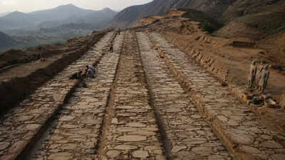
On the ground, archaeologists have confirmed the presence of nine trenches, layers of rammed earth, and compacted surfaces that can still be traced after thousands of years of erosion and land use change.What emerges is not just a section of road, but a reconstructed piece of an imperial artery some 900 kilometers long that connected the Qin stronghold near the modern city of Xi’an with the borderlands near present-day Baotou in Inner Mongolia.
Archaeologists have discovered a massive ancient “straight line” project that has shocked engineers
The Straight Road of Qin was established during the reign of Qin Shi Huang, after the unification of the Warring States in 221 BC.
Historical accounts, especially those preserved by historian Sima Qian, attribute the project to imperial orders intended to secure rapid military access to the northern frontier.These boundaries were defined by recurring conflict with the Xiongnu, whose movement forced the Qin state to rethink how to control distance itself. Rather than following natural lines, engineers sought directness on a large scale.
The road connects Xianyang near modern Xi’an with Jiuyuan, present-day Baotou, and passes through the wider Yulin area of Shaanxi Province.
What new exploration data reveals
Excavation data from the newly identified section reportedly reinforces what ancient texts had already suggested but had been unable to prove on a large scale. This was not a road adapted to the terrain. Documentation by archaeologists:
- Slope reinforcements hit the ground
- Compacted road pavements
- Trench-shaped paths cut through the high terrain
- The valleys were deliberately filled in to maintain alignment
- Consistent straight line direction across uneven terrain
Rammed earth is key to understanding durability. By compacting the soil in successive layers, the builders created a dense, stone-like foundation capable of supporting frequent heavy traffic without the use of modern binding agents.The width of the road, generally around 40 meters and extending in places to 60 metres, adds another layer of interpretation. It was not built for lane discipline but for parallel movement, with military columns, supply wagons, mounted messengers, and administrative convoys operating within a controlled corridor.
The discovery of the 13 kilometers and how it was found
The latter part was identified through a combination of historical mapping and remote sensing. The researchers compared old survey data with modern satellite images, looking for linear anomalies in areas where vegetation patterns deviated from natural formations.Field verification confirmed:
- Nine continuous ditch sections aligned in a straight axis
- Compact soil layers compatible with engineering road foundations
- Tread surface areas indicate constant traffic use
- Slope stabilization structures embedded in hill plots
