

- news
- Science News
- The Earth ‘rang like a bell’ for 9 days: Scientists trace the frightening signal to a mega tsunami in Greenland
Aa
Text size
- small
- Mediation
- big
1/7
The Earth ‘rang like a bell’ for 9 days: Scientists trace the frightening signal to a mega tsunami in Greenland
In September 2023, a massive landslide in Greenland’s Dixon Fjord triggered a massive tsunami, causing the entire planet to shake every 90 seconds for nine days. An unprecedented seismic rumble has been detected around the world. Satellites have now revealed the cause: the fjord’s resonant oscillations.
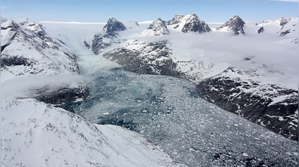
A 25.5 million cubic meter rockslide, driven by the melting of glaciers caused by climate change, fell into the 540-meter-deep fjord, triggering a 200-meter-high tsunami wave. This caused a long flow of water, similar to a huge bathtub, with the narrow confines of the fjord amplifying the effect.
Credit: National Geographic
2/7
What is the cause of the mega tsunami?
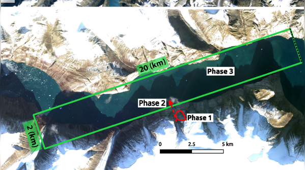
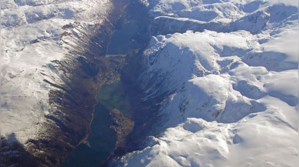
According to a study published in the journal Nature Communications, scientists quickly linked the signal to Greenland’s Dixon Fjord, a narrow inlet surrounded by 3,000-foot cliffs on each side. A 25.5 million cubic meter rockslide, caused by the melting of glaciers due to climate change, occurred in the 540-meter-deep fjord, generating a 200-meter-high tsunami. This created an expansive water flow, like a giant bathtub, and was exacerbated by the narrow fjord walls.
Credit: Wikipedia
3/7
Where is Dixon Strait located?
Dixon Fjord is the northernmost part of the King Oscar Fjord system. It is the largest branch of the Kimbe Strait. Its mouth opens on the northern side at the western end of the fjord, where there is an intersection of three branches, the other two being Rohs Fjord and Reeden Fjord.
Credit: Wikipedia
4/7
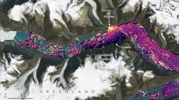
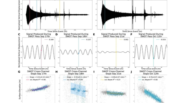
Satellites reveal “fjord resonance”
Copernicus Sentinel-2 and NASA’s Surface Water and Ocean Topography Satellite, known as SWOT images, revealed the mountain scar and traces of distant waves, confirming the occurrence of a 90-second wave, a standing wave that matches global signals. This constant resonance has transferred energy into the Earth’s crust, highlighting the dangers of landslides in the Arctic amid rising temperatures.
According to Nature Communications:
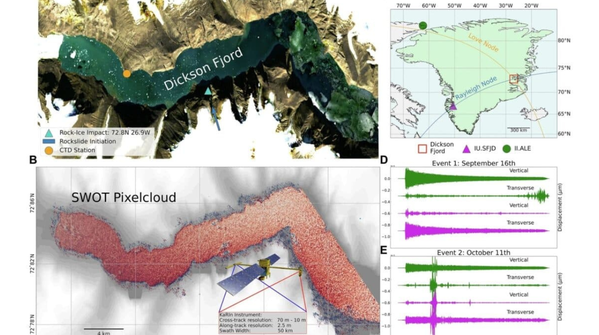
Seismic observations of very long period (VLP) signals for September and October.
ALE seismic station and cross-channel slope topography of ocean surface water (SWOT) mission.
Credit: Nature Communications
5/7
Scientists unveil cortical heartbeat
Seismic stations usually pick up irregular scratches during earthquakes. Here, traces showed smooth peaks, 90 seconds apart, that persisted for approximately two weeks with little decay.
No earthquake has ever generated such permanent global signals. One model estimated the floods to be 2.6 metres. Another 7-9 meters. Discrepancies arose from Dixon Fjord’s engineering assumptions, but both accurately identified the wave created by the landslide. “Simulating this long, flowing tsunami has proven very challenging,” said Alice Gabriel of the Scripps Institution of Oceanography at the University of California, San Diego.
Credit: NASA
6/7
History of Dixon Strait
Swedish Arctic explorer Alfred Gabriel Nethorst first surveyed Dixon Fjord in 1899 during the Swedish Greenland Expedition, searching for survivors of SA Andrée’s 1897 Arctic balloon project. He named it after financier Robert Dixon (1843-1924). In 1930, the Norwegian ship Veselikari reached its peak depth, reaching a depth of 568.75 metres.
Credit: Wikipedia
7/7
Climate warming and glaciers melting
Glacial ice previously stabilized the unstable slope, but rising air and sea temperatures have eroded this support. “Climate change is changing the Earth’s norms, unleashing atypical events,” Gabriel noted.
A similar instability in the Karat Strait (2017) resulted in a deadly tsunami, destroying eleven homes and claiming four lives. Dixon Fjord is located adjacent to the main cruise route. Although it is empty in 2023, the rise in Arctic tourism is exacerbating the threats. Officials are now looking to early warning systems that combine satellites and seismic waves.
Credit: Wikipedia
Follow us on social media
