

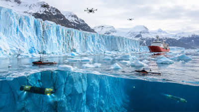
Some of the world’s most advanced robots prepare for an extraordinary expedition into one of the most dangerous environments on the planet. Starting next July, a fleet of self-driving drones, robotic boats, underwater vehicles, and smart sensors will travel to Greenland to investigate how glaciers are melting where they meet the ocean.
The mission, known as GIANT (Greenland Ice Sheet to Atlantic Tipping Points Due to Ice Loss), aims to collect data that scientists have never been able to collect before. By studying these rapidly changing glaciers in unprecedented detail, researchers hope to improve climate models, better understand future sea level rise, and identify early warning signs that major ocean circulation systems may be approaching dangerous tipping points.
Why scientists need robots to study Greenland’s glaciers
The boundary where Greenland’s glaciers meet the sea is among the least explored places in climate science. Huge icebergs, some more than 100 meters above the water, can break off without warning, sending house-sized icebergs crashing into narrow fjords. Beneath the surface, powerful meltwater plumes, eddy currents and hidden underwater ice formations create equally dangerous conditions.
These risks have prevented researchers from getting close enough to observe the thin boundaries where ocean water directly interacts with glacial ice. However, this narrow zone plays a crucial role in determining how quickly glaciers melt. Previous missions often focused on only one part of the system, such as the ice, ocean, or atmosphere. The new mission seeks to monitor them all simultaneously, something scientists say was impossible until recent advances in autonomous technology.As sea ice acoustics expert Hari Vishnu of the National University of Singapore notes, “We can’t model what we can’t observe,” highlighting one of the biggest challenges facing climate science today.
Meet the robot army heading to Greenland
The expedition will be launched from the Royal Research Ship Sir David Attenborough, a floating research laboratory that will spend most of July and August near the glaciers of the Kangerlussuaq fjord in southeast Greenland. A second Petermann Glacier expedition in northwest Greenland is already scheduled for next year to compare the behavior of glaciers in different environments.Instead of relying on a single machine, scientists assembled an entire robotic fleet, with each vehicle designed for a specific mission.Powerful drones will fly close to the ice faces, producing high-resolution maps and monitoring cracks that could cause icebergs to break off. A robotic surface ship equipped with sonar will navigate between floating icebergs to measure underwater ice faces without endangering researchers.
The autonomous underwater vehicles will dive hundreds of meters below the surface to record ocean temperatures, salinity, currents and the shape of the submerged ice.Among the most famous members of the fleet is Boaty McBoatface, the Internet-famous autonomous submarine that will explore beneath floating ice to map its geometry and study how ocean conditions affect glaciers’ behavior. Another thin underwater rover, just 23cm in diameter, will descend through holes drilled in the ice to investigate conditions beneath floating glaciers.The expedition will also deploy GPS-equipped “spears” that embed themselves in the ice surfaces and continuously transmit information about the movement of the ice. Tiny sensors will be installed on underwater ice slopes 50 to 100 meters below sea level, automatically adjusting their position as the glacier melts while recording temperatures, turbulence and melting rates in real time.
Why does the melting ice in Greenland affect the entire planet?
Greenland contains enough ice to raise global sea levels by about seven meters if it melted completely.
Although such a scenario would unfold over many centuries, the ice sheet is already losing mass much more rapidly than it was just a few decades ago.One of scientists’ biggest concerns is how this increased volume of freshwater might affect the Atlantic Overturning Circulation (AMOC), a vast network of ocean currents that helps regulate climate across much of the Northern Hemisphere. The system transports warm tropical waters north before cooler, denser waters sink into the depths of the Atlantic Ocean and flow south again.As more fresh water enters the North Atlantic, it reduces the salinity and density of seawater, making it difficult for this cycle to continue. Earth scientist Christine Poinar compares this process to adding cold tap water to a carefully balanced bowl of warm, salty soup. She says that too much fresh water can gradually impair blood circulation.Scientists believe that much evidence already points to a weakening of the AMOC in recent decades.
If the slowdown continues significantly, it could change rainfall patterns, affect agriculture, alter marine ecosystems, and affect temperatures across Europe and other parts of the world.
Climate models still cannot explain the hidden processes
Although climate models are becoming increasingly sophisticated, they still oversimplify many of the processes associated with glacier melting. Most people assume that warm ocean water transfers heat directly to the ice, causing it to melt.
Researchers now suspect that the reality is considerably more complex.One mystery involves tiny bubbles of ancient air trapped inside glacial ice. As the ice melts, these bubbles escape and rise through the surrounding seawater. Scientists believe they may increase mixing between warm ocean water and the glacier’s surface, allowing more heat to reach the ice than current models predict.Researchers also hope to understand why glaciers sometimes release huge icebergs through dramatic calving events, while remaining relatively stable at other times.
Observing these processes with millimeter precision can reveal how small physical changes eventually lead to much larger avalanches, improving future predictions of sea level rise.
Artificial intelligence will decide where the robots go
Artificial Intelligence will play a vital role throughout the mission. Before any robot enters the water, AI algorithms will combine satellite images with existing information about snowfall, glacier movement, ocean temperatures and other environmental conditions.Instead of distributing instruments evenly across a region, the system will identify areas where scientific uncertainty is greatest. Researchers refer to these locations as “blind spots,” allowing the mission to focus its observations where new data will have the greatest impact on climate research.
A major upgrade to climate forecasting
Information collected during the mission will be incorporated into the UK Earth System Model, one of Britain’s leading climate simulation systems.
Scientists expect the mission to provide one of the most significant improvements yet to glacier modeling, because it will provide measurements from one of the least observed parts of Earth’s climate system.More accurate simulations could improve predictions of glacier retreat, iceberg formation, sea level rise, and changes in ocean circulation. The researchers also hope that the results will contribute to the creation of an early warning system capable of detecting when rivers start glaciating Greenland is approaching climate tipping points that may eventually have global consequences.
A new chapter in climate exploration
The giant mission represents a fundamental shift in how scientists study Earth’s inaccessible environments. Instead of relying primarily on satellites or incidental measurements taken on ships, researchers will simultaneously monitor Greenland’s glaciers from the air, across their surfaces, and in the depths of the ocean using a coordinated fleet of autonomous machines.Beyond demonstrating the capabilities of modern robotics, the mission could answer some of the most pressing questions in climate science about how glaciers respond to a warming world. If successful, it will provide the detailed observations that scientists have sought for decades, helping to improve climate predictions while providing a clearer picture of how one of the planet’s largest ice sheets will shape the future of Earth’s oceans, weather patterns and coastlines.