

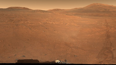
NASA’s Perseverance rover has captured a new sweeping panoramic image of a rugged Martian area nicknamed “Crocodile Bridge,” revealing one of the oldest known Martian landscapes in exquisite detail.
The 360-degree mosaic, created using the rover’s Mastcam-Z camera system, brings together 980 images taken across multiple Martians, or Martians. The area is located on the edge of Jezero Crater, and contains ancient rocks believed to date back to the early formation of the solar system. Scientists say the terrain could preserve valuable clues about Mars’ early crust, atmosphere and long-lost watery past.
Inside the Crocodile Bridge area on Mars
The newly released panorama was compiled using Perseverance’s Mastcam-Z camera system.
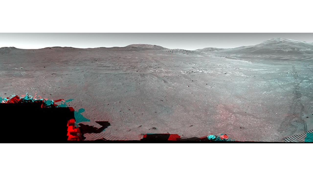
According to NASA, 971 images were taken on December 18, 2025 during the mission’s 1717th Sol, while another nine images were taken on January 25, 2026 during the 1754th Sol.The natural-color panorama has been processed to resemble how the human eye sees the surface of Mars. NASA has also released enhanced color and 3D versions of the panorama, which help highlight fine geological details and elevation changes across the rocky terrain.
The images reveal a reddish-brown plain strewn with rocks and bordered by hills and hills on the horizon. Tracks left by the rover extend across the surface, indicating Perseverance’s path along the crater rim.The Crocodile Bridge area represents a transition to another area of scientific interest called Lac de Charmes, which Perseverance is expected to explore for several months later this year.Scientists are particularly interested in this area because the rocks around the edge of Jezero Crater are thought to be among the oldest preserved anywhere in the solar system. NASA describes them as geological time capsules from a period when Mars’ crust and atmosphere were still forming.Unlike Earth, Mars does not have active tectonic plates that are constantly recycling and reshaping its surface. This allowed extremely ancient terrain to remain preserved for billions of years, giving researchers a rare opportunity to study material from the early history of the Red Planet.
Why is it called “Crocodile Bridge”?
NASA has not officially explained the origin of the nickname “Alligator Bridge,” but it appears to be an informal operational name used by the rover team to identify a particular landscape feature or path.Mars mission teams often assign informal names to terrain, rock formations, and exploration areas to simplify navigation and scientific discussions. In this case, the surname refers to a transitional area that leads to the “Lac de Charmes” region.The name does not indicate that there are actual crocodiles or bridges on Mars. NASA has also not confirmed the exact inspiration behind the title, although it may relate to the shape or appearance of the terrain.
Exploring the ancient Martian lake system
Jezero Crater was chosen as the landing site for the probe because scientists believe it once contained a lake and a river delta billions of years ago. Previous orbital observations have revealed minerals that typically form in water-rich environments.One of the rover’s primary goals is to search for signs that microbial life may have existed in these ancient habitats. Perseverance is also collecting samples of rocks and rock debris that could eventually be returned to Earth for detailed laboratory analysis in a future mission.By exploring sites like Crocodile Bridge, researchers hope to better understand whether Mars once had conditions capable of supporting life.
The technology behind the photos
The panoramic image was captured using Mastcam-Z, an advanced stereo camera system mounted on the rover’s mast. The tool can zoom in, create 3D images, and examine geological formations from long distances.Mastcam-Z operations are led by Arizona State University in collaboration with Malin Space Science Systems and the Niels Bohr Institute, which contributed to the calibration systems used in the cameras.High-resolution images allow scientists to study rock layers, identify mineral differences, and select sites for closer investigation.
A mission focusing on Mars’ ancient past
The Perseverance mission, managed by NASA’s Jet Propulsion Laboratory on behalf of NASA, is part of NASA’s Mars Exploration Program.Since landing on Mars in February 2021, the rover has explored ancient river channels, sedimentary deposits and volcanic terrain across Jezero Crater. Each new region helps scientists reconstruct the environmental history of Mars and investigate whether the planet was once habitable.The Alligator Bridge Panorama adds another important chapter to this mission, providing a detailed look at a landscape that has remained largely unchanged since the early days of the solar system.


